Burr Trail Utah. Photo ID 102907343 © Brian Wolski | Dreamstime.com
Spring months offer the prime season to embark on an exploration of unparalleled desert beauty in Southern Utah's Grand Staircase-Escalante National Monument. These roads lead to an unveiling of not only a landscape that's etched with beauty but also a treasure trove of rich history waiting to be discovered.
Venture into one of the most remote and enchanting corners of the country, where every twist and turn reveals towering mesas, hidden canyons, and a symphony of colors that have evolved over eons.
The Grand Staircase-Escalante National Monument calls you to chart a course through its storied terrain, where echoes of the past connect with the present day to create some of the best road trips in the country.
Nestled in the heart of the American Southwest, Southern Utah lures in adventure seekers, history enthusiasts, and nature lovers alike with its awe-inspiring landscapes and rich tapestry of history. As you journey through this captivating region, you're not just exploring the land – you're stepping into a living history that dates back millions of years.
Cliff dwellings
Long before European settlers arrived, Indigenous peoples thrived in this arid terrain.
Tribes like the Navajo, Ute, and Paiute left their mark on the land, living in harmony with its challenges and blessings. Petroglyphs etched into rock walls and ancient dwellings perched within cliffs offer glimpses into their vibrant cultures and spiritual connections to the earth.
Grand Staircase and slot canyon - Utah. Photo ID 81640989 © Galyna Andrushko | Dreamstime.com
The mid-1800s brought a wave of pioneers seeking a new beginning. Southern Utah's rugged terrain presented challenges, but also opportunities for those willing to endure.
As you traverse Scenic Byways like Highway 12 or the All-American Road of Scenic Byway 143, you'll follow in the footsteps of these early adventurers, witnessing the same breathtaking vistas they marveled at so many years ago.
The landscape
A geological masterpiece sculpted by time, the landscape of Southern Utah begins with the Colorado Plateau, upon which Southern Utah rests.
The massive area encompasses everything from the natural rock arches of Arches National Park and the deep canyons of Canyonlands National Park to the waters of Lake Powell, with Bryce Canyon National Park, Zion National Park and Capitol Reef National Park anchoring the land in between.
Some of Southern Utah’s most picturesque landscapes can be seen without paying an entrance fee.
Spanning nearly 1.9 million acres, the rugged and remote terrain of the Grand Staircase Escalante National Monument is a scenic, but lesser known destination.
Part of what makes visiting Escalante National Monument so special and unique, is its limited access to trails and the land itself. Few can be reached on paved roads. In fact, most are accessed via unpaved dirt roads.
Cottonwood Canyon Road, Utah. Photo ID 11182883 © Gelyngfjell | Dreamstime.com
These backroads throughout the monument not only offer access to numerous trailheads, they also offer exceptional scenic driving potential. A few designated scenic drives take you through some of the most scenic sites within and surrounding the national monument.
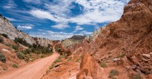
Cottonwood Canyon Road
Connecting the scenic byway HWY 12 and HWY 89, Cottonwood Canyon Road is a 47-mile unpaved driving route.
Accessible with a sturdy 2WD car, 4x4 is preferred, this scenic road, often considered a hidden treasure, offers an exceptional experience for adventurers seeking to immerse themselves in the raw beauty of the American Southwest.
Even if you don’t get out of your car, your vehicle becomes a vessel for exploration, carrying you through a mesmerizing tableau of jagged cliffs, sculpted sandstone formations, and the vibrant hues of the high desert.
But if you choose to explore, there are several hiking and backpacking opportunities along this route. A beginner hike at Cottonwood Wash Narrows is a must, along with a stop at the Grosvenor Arch. Spend some time at Kodachrome Basin State Park with popular hiking trails like the Angel’s Palace and the Grand Parade Trail.
Hole-in-the-Rock
Travel like the pioneers did on the 62-mile Hole-in-the-Rock Road. Follow the original route of the pioneers who ran the Hole-in-the-Rock expedition in 1880.
This route, more than just a dirt road, is an adventure that retraces the footsteps of pioneers who embarked on an audacious journey through the rugged terrain. The expedition is best known for the 250 Mormon pioneers who blasted a “hole in the rock” to access the other side of the Colorado River, which is now Lake Powell.
Catching the route just south of the town of Escalante, off HWY 12, you head south from there all the way to Lake Powell. The drive takes you through a colorful blend of red rocks and vegetation, unique rock formations, and expansive vistas that tell a story of determination, exploration, and the remarkable forces of nature.
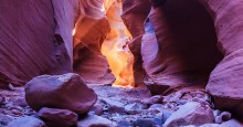
At mile 55.5, drivers will reach the famed Hole in the Rock, where most people get out and hike the rest of the way. Popular side treks from this road are the 11 miles to Devil’s Garden and the 26 miles to the famous slot canyons of Peek-a-boo and Spooky Gulch.
Much of this route is within the national monument and requires a high clearance 2WD vehicle. Plus, numerous side roads that are best explored with detailed knowledge of the area and a 4x4 vehicle.
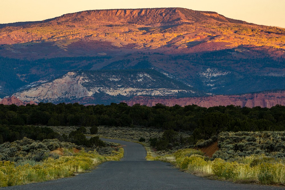
Burr Trail
Originally a cattle trail, the Burr Trail is a paved gravel road that takes you through some of the most impressive scenery in Southern Utah — passing through the National Monument, Capitol Reef National Park and the Glen Canyon National Recreation Area.
The meandering highway is filled with a wide-open desert landscape adorned with juniper trees and distant mountain views. If you begin in the town of Boulder, Utah, in the Escalante National Monument and continue to Capitol Reef NP, this road is paved.
After passing through a varied terrain of slickrock and sandstone sand dunes, the descent into Long Canyon begins. The drive through the canyon is one of shock and awe and a checklist destination for any dedicated road-tripper.
This particular stretch of road has been used in a number of car manufacturers commercials. There are several trails that are found in the canyon including Circle Cliffs and Waterpocket Fold.
These routes are best traveled during dry conditions from spring to fall. Summers are hot, so bring extra water. There aren’t many amenities or conveniences along the way, so be sure to gas up before hitting the road.
Check weather conditions before heading out, heavy rainfall can render some of these dirt roads impassable.
An All-American Road
For the ultimate scenic road trip, drive the Scenic Highway 12.
The epic 123-mile route follows some of the most beautiful landscape of the American Southwest, which is why it was designated as an “All-American Road” in 2002 by the Federal Highway Administration.
It’s not just its breathtaking scenery that lures in travelers, but how the road follows and clings to the land, making it feel almost a part of the landscape. The paved two-way road climbs to the famous "Hogsback” stretch with its hairpin curves and steep cliffs, and it brings drivers to scenic vista points that offer views for as far as the eye can see.
The scenic byway connects U.S. 89 near Panguitch with S.R. 24 near Torrey, Utah. As travelers make their climb into the Dixie National Forest from Torrey, one of the best spots for a scenic overlook is at the road’s summit at 9,000 feet.
Take in the grandeur of land below with views of the contrasting red rocks of Capitol Reef, the distant Henry Mountains and the expansive desertscape of the Grand Staircase-Escalante.
Connecting Capitol Reef National Park and Bryce Canyon National Park, the road winds through parts of the Grand Staircase and nearby state parks such as Kodachrome Basin, Escalante Petrified Forest, Anasazi State Park Museum. This highway also provides direct access to the off-the-beaten-path scenic byways.
The drive can be completed in about three hours, but this road trip could be done in four days– allowing for ample time to stop, visit the parks, hike the trails and take in the scenic landscape.
While camping is available along the highway, there are several notable locations for overnight stays.
The only two designated trails (with signs) in the Grand Staircase can be accessed directly from HWY 12 as well — Upper and Lower Calf Creek Falls. Upper Calf Creek is a short two-mile hike round trip, but with a steep climb to the waterfalls.
Lower Calf Creek Falls is longer at six miles but is mostly flat. This trailhead is well-marked from the road and provides ample parking. The trailheads are not near each other, they are spaced about four miles apart.
Hell’s Backbone
If the 123 miles of HWY 12 isn’t enough, drivers can add to the route by way of the Hell’s Backbone. Named as one of the most dangerous roads in America, Hell’s Backbone links the two isolated communities of Boulder and Escalante.
The route is infamous for its mountainous climb reaching the edge of The Box and Death Hollow where it soars over 9,000 feet. But the part that has most drivers white-knuckling the steering wheel is when it follows a narrow ridgeline that offers little to no barrier between you and the sheer cliffs on either side.
To take Hell’s Backbone, pull off HWY 12 about five miles south of Boulder. It will connect with the Posey Lake/Pine Creek Road, which takes you back down to Escalante. There is no cell service on this road and it can be tricky to find, so keep your eye out. The route is closed during the winter months.
As you explore the history and landscapes of Southern Utah, you become part of an ongoing narrative. The delicate balance between preservation and enjoyment underscores the region's modern identity. Conservation efforts, guided local tours and responsible travel practices help ensure that these treasures remain for generations to come.
Visitor Tips
Be sure you know ahead of time which route you want to explore or if you plan to take a few off-the-beaten-path routes as this will determine your vehicle type.
2WD vehicles are fine for Hwy 12 and Burr Trail, which are both paved. Possibly the upper stretches of Hole-in-the-Rock Road, but be sure to call ahead for road conditions for this route.
High clearance is needed for most of the dirt roads in the monument.
4WD vehicles are necessary for travel on the Kaiparowits Plateau, Cottonwood Canyon road and Hole-in-the-Rock Road after recent floods. Plus, plan to drive a 4WD vehicle if you plan to take the spurs off of the main dirt roads.
There are no gas stations inside the Grand Staircase monument, only the gateway towns like Escalante, Panguitch, and Bryce Canyon City offer gas services. There are several restaurant options as well as grocery markets, but don’t expect Wal-Marts or Targets nearby.
Weather in Southern Utah is generally hot, especially in summer. But even the temperatures in autumn can rise, so be sure to bring plenty of water with you. Water options are scarce due to limited amenities.
Bring a hat for sun protection as there isn’t much shade. Pack layers for warm days and cool nights, where you might find yourself reaching for a jacket and gloves — especially if camping.
Sunscreen is a must as well. Sun shirts are better for full protection. Either way be sure you are protected from the sun.
Remember there is no official entrance into the monument, but there are four visitor centers that surround the area.
For more information, be sure to visit the BLM’s official website.
Copyright © 2026 by Sensible Driver. All rights reserved.